I. General TLD Policies
E1. General[1]
The attached Executive Summary provides an overview of the goals and implementation of the .geo infrastructure. Please also refer to the Glossary for the definition of terms (italicized when first called out). To avoid confusion, we will consistently use the terms "gTLD registry" and "GeoRegistry" to mean two different categories of participants, instead of the single term "registry." These policies are promulgated by SRI as the Sponsoring Organization.
The distributed nature of the .geo infrastructure demands that all domain name owners (GeoRegistries) within the hierarchy adhere to well-defined standards and protocols for the geodata registration and discovery services they will provide. The standards, protocols, minimum performance criteria, and fees for GeoRegistries will be defined by the Sponsoring Organization (Sponsor) in an open forum - the .geo Forum - that will include GeoRegistries, GeoRegistrars, data providers, international standards organizations, and, most important, end users. We expect .geo's standards and services to evolve significantly over time, and new services to be defined that fit naturally into this hierarchy or into related hierarchies.
Because of the need for adherence to defined standards and protocols, candidate GeoRegistries must be accredited before registering a domain name and delegating it to one of their cell servers. Furthermore, they must be supervised on a continuing basis to ensure that they are meeting minimum performance criteria. Initially, candidate GeoRegistries will be accredited, and their performance monitored, by the Sponsor's designated Accreditor (see Section III below). In the future, we propose to use a distributed model for accreditation and supervision, in which several trusted organizations will be responsible for accrediting and supervising GeoRegistries, either on a regional basis or on a per GeoRegistry basis, based on the Sponsor's criteria.
GeoRegistrars will offer Data Providers an easy method for registering geodata into a
GeoRegistry. GeoRegistrars also must be
accredited. As described below, the
accreditation criteria for GeoRegistrars will be less stringent than those for
GeoRegistries. Indeed, the Sponsor will
offer open-source software to make it as simple as possible for any
organization, including current DNS registrars, to be accredited, thereby providing
immediate open competition for this service.
E2. TLD String
Our proposed TLD string is "GEO."
E3. Naming Conventions
Everything in the world has one or more locations. The .geo infrastructure will categorize these locations according to a DNS hierarchy of geographic domain names. Unlike other proposed TLDs in which domain names are assigned arbitrarily, in .geo the hierarchical domain name will have real meaning: it will represent a region bounded by latitude and longitude. Such a region will be called a cell. Following are example applications of this schema.
- The geographic domain name 20e30n.geo identifies the 10-degree x 10-degree cell whose southwest corner is located at 20 degrees east, 30 degrees north.
- The geographic domain name 2e4n.10e50n.geo identifies the 1-degree x 1-degree cell whose southwest corner is located at 12 degrees east, 54 degrees north.
- The geographic domain name 11e21n.3e7n.30e10n.geo identifies the 1-minute x 1-minute cell whose southwest corner is located at 33 degrees, 11 minutes east and 17 degrees, 21 minutes north.
An XML name schema file downloadable from the URL nameschema.geo will specify the exact form of the hierarchy and the naming convention for cells.
An example name schema file for a three-level .geo hierarchy is the following:
<?xml
version="1.0"?>
<hds:hdschema
xmlns:hds="http://www.dotgeo.org/hdschema/">
<hds:CoordinateSystem
typee="Earth WGS84 lat-long" indexrank="2"
cellrank="3"/>
<hds:Access
type="XML" url="e:/source/dotgeo/xml/db.xml"/>
<hds:Levels>
<!-- 10 degree cells -->
<hds:Level description="90
degree cells">
<hds:Cells
name="%de%dn">
<hds:CellLimit
n="1" inc="10" min="0" max="350"/>
<hds:CellLimit
n="2" inc="10" min="10" max="170"/>
</hds:Cells>
<hds:Cell
name="northpole">
<hds:CellLimit
n="1" min="0"
max="360"/>
<hds:CellLimit
n="2" min="170"
max="180"/>
</hds:Cell>
<hds:Cell
name="southpole">
<hds:CellLimit
n="1" min="0"
max="360"/>
<hds:CellLimit
n="2" min="0"
max="10"/>
</hds:Cell>
<!-- 1 degree cells
-->
<hds:Level
description="10 degree cells">
<hds:Cells
name="%de%dn">
<hds:CellLimit
n="1" inc="1" min="0" max="9"/>
<hds:CellLimit
n="2" inc="1" min="0" max="9"/>
</hds:Cells>
<!-- 1
minute cells -->
<hds:Level
description="1 minute cells">
<hds:Cells
name="%de%dn">
<hds:CellLimit
n="1" inc="1" min="0" max="9"/>
<hds:CellLimit
n="2" inc="1" min="0" max="9"/>
</hds:Cells>
</hds:Level>
</hds:Level>
</hds:Level>
</hds:Levels>
</hds:hdschema>
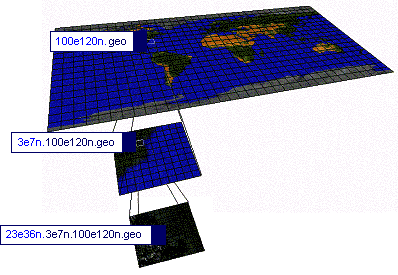
Figure 1 .geo Hierarchy
The .geo hierarchy is illustrated in Figure 1.
Each geographic cell in .geo will be assigned at least one server, called a cell server. Cell servers will be maintained by organizations called GeoRegistries, who will be contractually obliged to provide services for the registration and discovery of geodata according to protocols and minimum service criteria defined by the Sponsor. Briefly, a cell server assigned to a given cell will be responsible for storing and responding to queries for geodata that lie within its cell boundary. [2]
Storage and placement of example classes of geodata is illustrated in Figure 2. The basic rules are: (1) Geodata is placed at a level in the hierarchy such that its geographic coverage overlaps no more than four cells; and (2) geodata is placed within the cells that overlap its geographic coverage. Geodata with large geographic coverage, as in a country map, would be placed at the ten-degree level, while geodata with small geographic coverage, as in a building, would be placed at the one-minute level.
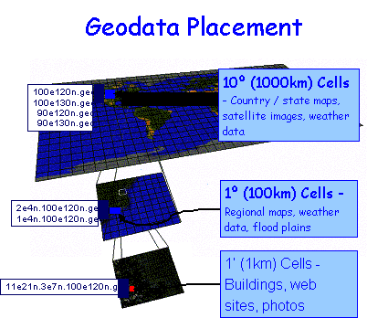
Figure 2. Storage and placement of example classes of geodata.
GeoRegistries will charge a fee, set by the Sponsor, for registering, altering, and deleting a geodata record. GeoRegistries will not charge a fee for the discovery of geodata, unless they are doing so on behalf of Data Providers (e.g., a subscription fee for private data). GeoRegistries may offer other services to Data Providers, such as data hosting, which may be performed at market prices. The flow of fees is illustrated in Figure 3.
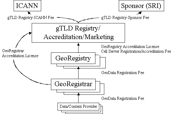
Figure 3. Fee flow diagram.
GeoRegistries will be identified by their brand name. For example, a GeoRegistry named "acme" may have a server (say, server1.acme.com) that is assigned to cells 10e20n.geo, 10e30n.geo, and 2e5n.10e30n.geo. This means that the cell server domain names acme.10e20n.geo, acme.10e30n.geo, and acme.2e5n.10e30n.geo are all registered in the .geo gTLD registry, and are all delegated to server1.acme.com.
Several GeoRegistries may have cell servers assigned to the same cell. For example, GeoRegistries "acme," "best," and "first" could each have a server assigned to the 20e30n.geo cell, with cell server domain names acme.20e30n.geo, best.20e30n.geo, and first.20e30n.geo. This will provide competition amongst GeoRegistries because end users will have the option of accessing their preferred GeoRegistry to conduct their research.
One special GeoRegistry must have a server assigned to every cell on the planet. This GeoRegistry will be called the default GeoRegistry and named "earth." (The names of the other planets will be reserved for interplanetary geodata.) The default GeoRegistry will be used when client queries do not specify a GeoRegistry name, or when the specified GeoRegistry does not have an assigned cell server.
Since only one cell server can carry the default name, the default GeoRegistry will be maintained by one or more organizations (e.g. corporate entity, not-for-profit organization, government agency) on a regional basis. For example, organization A may be assigned cells covering parts of North America, while organization B may be assigned cells covering parts of Europe. Organizations will be required to meet stringent performance and service standards and will be allowed to compete on a regular basis for the assignment of the "earth" default cell server because the award of the "earth" brand name will be granted for a defined period.
In addition, each accredited GeoRegistry and GeoRegistrar
will be assigned a courtesy second-level domain name (SLD) under .geo to
provide information about their services.
The reserved SLD "www" will be used to provide overall
information about the .geo gTLD, including a list of available GeoRegistries
and GeoRegistrars. We will also reserve
the brand names (and corresponding SLDs) land, sea, air, space, and id for
future expansion of related hierarchies and services.
E4. Registrars
We do not anticipate the need for domain name registrars per se during the initial test period, because GeoRegistries will communicate directly with the gTLD registry to register cell server domain names. Instead, traditional domain name registrars (and other organizations that do not currently provide domain name registration services) can be accredited as GeoRegistrars, thereby providing significant competition amongst GeoRegistrars. GeoRegistrars will automatically be participants in the Sponsor's .geo Forum for defining and evolving standards.
E4.1. Domain Name Holder Interactions
Domain name holders in the .geo hierarchy (i.e., GeoRegistries) will deal directly with the Accreditor and gTLD registry. They will be accredited for doing this as well as for performing their primary duties of providing geodata registration and discovery services. GeoRegistries will automatically be participants in the Sponsor's .geo Forum for defining and evolving standards, protocols, and minimum performance criteria.
E4.2. Roles, Functions, and Responsibilities
E.4.2.1 Registry Operator Roles, Functions, and Responsibilities
The gTLD registry operator supporting the .geo TLD will provide all the systems, software, hardware, facilities, infrastructure, and staff in order to:
- Maintain a central database (the gTLD registry) of all domain name maps according to the hierarchical name schema provided by the Sponsor at URL nameschema.geo.
- Provide a means for accredited GeoRegistries to register cell server domain names in the hierarchy. Ensure that the shared registry system is accessible only to accredited GeoRegistries.
-
Maintain a single database for up-to-date and verified
contact information for all delegations made in the .geo hierarchy by
GeoRegistries. The database should
support a searchable WHOIS resource that contains, or provides access to, a
minimum descriptive record of all domain name registrations at all levels. The
database and WHOIS resource should be secure; should allow for multiple string
and field searching through a free, public, Web-based interface; and should
consist of at least the following elements:
- The name of the delegation.
- The name of the domain registered.
- The IP address of the primary nameserver and secondary nameserver(s) for the delegation and registered domain name.
- The corresponding names of those nameservers.
- The identity of the delegated manager under which the name is registered.
- The date of delegation.
- The creation date of the registration.
- The name and postal address of the delegated manager.
- The name, postal address, e-mail address, voice telephone number, and fax number of the technical contact for the delegated manager.
- The name, postal address, e-mail address, voice telephone number, and (where available) fax number of the administrative contact for the delegated manager.
- The name, postal address, e-mail address, voice telephone number, and (where available) fax number of the technical contact for the domain name holder.
- The name, postal address, e-mail address, voice telephone number, and (where available) fax number of the administrative contact for the domain.
- Escrow registry data on a weekly basis, or more frequently.
- Provide bulk access to zone files.
- Provide the zone files, machines, and Internet connectivity to respond to domain name queries for those zones. Maintain these servers for continued operation, functionality, and accessibility to the Shared Registry System (SRS).
- Collect a fee per domain name (to be negotiated with the Sponsor and ICANN).
- Comply with and enforce (as appropriate) ICANN polices.
- Provide engineering ("help desk") support to GeoRegistries.
- Pay gTLD registry fees to ICANN and to the Sponsor.
The gTLD registry will be
prohibited from:
- Collecting data not essential to registration in the hierarchy.
- Prohibiting non-Sponsor/ICANN approved GeoRegistries from accessing the data.
E.4.2.2 Registrar Roles, Functions, and Responsibilities
We do not anticipate the need for domain name registrars per se during the initial test period, because GeoRegistries will communicate directly with the gTLD registry to register cell server domain names. Instead, traditional domain name registrars (and other organizations that do not currently provide domain name registration services) can easily be accredited as GeoRegistrars, thereby providing significant competition amongst GeoRegistrars.
E4.3. Selection and Accreditation
We do not anticipate the need for domain name registrars per se during the initial test period, because GeoRegistries will communicate directly with the gTLD registry to register cell server domain names. Instead, traditional domain name registrars (and other organizations that do not currently provide domain name registration services) can easily be accredited as GeoRegistrars, thereby providing significant competition amongst GeoRegistrars.
E4.4. Number of Registrars
We do not anticipate the need for domain name registrars per se during the initial test period, because GeoRegistries will communicate directly with the gTLD registry to register cell server domain names. Instead, traditional domain name registrars (and other organizations that do not currently provide domain name registration services) can easily be accredited as GeoRegistrars, thereby providing significant competition amongst GeoRegistrars.
E4.5. Pre-Selection of Registrars
We do not anticipate the need for domain name registrars per se during the initial test period, because GeoRegistries will communicate directly with the gTLD registry to register cell server domain names. Instead, traditional domain name registrars (and other organizations that do not currently provide domain name registration services) can easily be accredited as GeoRegistrars, thereby providing significant competition amongst GeoRegistrars.
E4.6. Selection Criteria
We do not anticipate the need for domain name registrars per se during the initial test period, because GeoRegistries will communicate directly with the gTLD registry to register cell server domain names. Instead, traditional domain name registrars (and other organizations that do not currently provide domain name registration services) can easily be accredited as GeoRegistrars, thereby providing significant competition amongst GeoRegistrars.
E4.7. TLD Policy Enforcement
The GeoRegistries and GeoRegistrars will be subject to specific performance criteria, to which they will agree as a condition to accreditation. They will be supervised on a continuing basis and audited periodically to ensure that they meet the performance criteria. Failure to meet the performance criteria and to correct such failure within a set period of time will result in the suspension of the accreditation, either at the global level or for the specific cell affected, as applicable, until the applicant can provide substantial evidence of its ability to meet the performance criteria. Repeated failure to meet the performance criteria will result in the loss of accreditation.
E5
E5.1. Measures to Discourage IP Infringement
To avoid disputes with respect to trademark infringement, GeoRegistry applicants will have to pass the accreditation process performed by the Accreditor. The request for accreditation will include, among other things, proof that the entity has been commonly known by the brand name for which it requests GeoRegistry accreditation, and proof of ownership and registration of the trademark or service mark associated with the GeoRegistry domain names. The accreditation process will include an examination (similar to that which is conducted by the United States Patent Trademark Office) with an in-depth search for similar trademark or service mark registrations, worldwide. If the examination uncovers trademark or service mark registrations for the same brand name owned by third parties anywhere in the world, the applicant will be required to provide proof that it has cleared any potential conflict with these third parties.
After the Accreditor has determined that the application for GeoRegistry is acceptable, the request for the brand name application will be posted on the gTLD Web site for comment and opposition for a period of sixty days. Third parties' oppositions against the proposed accreditation will be resolved using ICANN's Uniform Domain Name Dispute Resolution Policy ("UDRP"). Subsequent disputes with respect to brand name or trademark infringement or cybersquatting issues will also be resolved using the UDRP.
Disputes with respect to the content, substance or subject matter of geodata registrations will be examined in accordance with a process similar to those set forth in the UDRP and the Digital Millennium Copyright Act (a notice-and-take-down procedure). A petitioner who requests that content be removed, or that access to content be disabled, will be required to make a sworn statement that it has a good faith belief that use of the material in the manner complained of is not authorized by the copyright owner, or infringes upon other rights of the complainant. The complainant will also be required to bring sufficient evidence of infringement. Upon receipt of such evidence, the GeoRegistrar will be requested to expeditiously remove or disable access to the material that is the subject of the dispute. The GeoRegistrar will display on its Web site, information about the designated agent to receive notifications of alleged infringement. Proceedings will be conducted before one of the administrative dispute resolution service providers identified by ICANN, listed at http://www.icann.org/en/dndr/udrp/approved-providers.htm. The decision will be implemented within ten (10) days unless the GeoRegistrar (or GeoRegistry, as applicable) has received from either party a complaint filed and stamped by the clerk of the court, that the losing party has commenced a lawsuit against the other party. The complainant will then be responsible for pursuing its remedies in court. In this case, the materials in dispute will be removed or disabled until the parties provide the applicable GeoRegistrar with a copy of the court order or settlement agreement, providing for the reinstatement of the materials.
E5.2. Pre-Screening Measures
Since accreditation will be a stringent process to ensure
the integrity of the proposed infrastructure, we do not anticipate a need for
pre-screening measures in addition to those in the accreditation process.
Applicants to become GeoRegistries will be required to provide, among other things, (a) proof of good corporate standing; (b) audited financial information for at least the prior twelve (12) months; (c) a plan for the acquisition, operation and maintenance of the needed resources that provide sufficient evidence of the financial fitness of the applicant, and its ability to perform the registry tasks; and (d) proof of ownership and registration of the trademark or service mark associated with the name of the GeoRegistry they wish to register. The Accreditor will conduct an examination of the application. The examination will provide the opportunity for a dialogue with the applicant that will allow an in-depth evaluation and screening of the applicant.
Substantial non-refundable application fees will also ensure that only qualified candidates apply for accreditation.
E5.3. Practices To Minimize Abusive Registrations
The accreditation process and the high application fees for GeoRegistries and GeoRegistrars should deter abusive registrations for GeoRegistries and GeoRegistrants.
Registration of geodata that include URLs will be limited or contingent upon the existence of an underlying domain name, with related content. To register geodata, a data provider will have to provide proof of the existence of an operational website, with relevant content.
The Sponsor will encourage the use of Validators. The Sponsor will also propose a code of conduct whereby Data Providers, as part of their registration application, will represent that the geodata or linked information is not defamatory, abusive or illegal, and does not violate any rights of any third party; and that to the best of the registrant's belief the geodata or linked information is accurate, complete and up-to-date.
E5.4. Measures to Assure Compliance to Trademark and Anti-Cybersquatting Legislation
We will adopt the UDRP.
E5.5. Special Protections for Famous Trademarks
The accreditation process for GeoRegistries will include trademark clearance, with a review of trademark registrations worldwide. This trademark clearance process, together with the posting of the accreditation request, should allow trademark owners to "watch" the applications, and file oppositions as appropriate, before the accreditation is granted.
E5.6. Maintenance of Whois data
The gTLD registry will adopt the same requirements as current registrars, per the "ICANN Registrar Accreditation Agreement," Paragraph II.F.
E6. Dispute Resolution
E6.1. Implementation of the Uniform Dispute Resolution Policy
We will adopt the UDRP. GeoRegistrars and GeoRegistries will be required to adopt the UDRP as a condition for accreditation. The data providers, will also be required to agree to the UDRP as a condition for the registration of their geodata.
E6.2. Additional, Alternative, or Supplemental Dispute Resolution Procedures
To prevent disputes, we will encourage Data Providers to
(a) have their geodata validated by a reputable entity, and (b) use a
"seal program" that would evidence their commitment to abide by
certain basic principles, such as accuracy and completeness of the information
provided.
E7. Data Privacy, Escrow, and Whois
The gTLD registry will adopt the same requirements as
current registrars, per the "ICANN Registrar Accreditation
Agreement," Paragraph II.F.
E8. Billing and Collection
Please refer to Section D15.2.6.
E9. Services and Pricing
Please refer to Sections D13.2.1.
E10. Other
GeoRegistries will be accredited before registering a domain name. Once they have begun operations, they will be supervised on a continuing basis to ensure that they are meeting minimum performance criteria. Initially, candidate GeoRegistries will be accredited, and their performance monitored by the Sponsor-designated Accreditor. In the future, we propose to use a distributed model for accreditation and supervision, in which several organizations will be responsible for accrediting and supervising GeoRegistries, based on uniform criteria.
GeoRegistrars also must be accredited in order to provide GeoRegistrar services.
The quality of geodata will be assured through validation
and seal programs.
II. Registration Policies during the Start-Up Period
E11. General
E12. Registration at TLD Opening
Due to the unique nature of this domain, and the required GeoRegistry accreditation process, we do not anticipate an initial rush for registration of domain names.
E12.1. Projected Registrations
In addition to the default GeoRegistry called "earth", which must have a cell server assigned to every cell, we anticipate at least full coverage by at least one brand name GeoRegistry for populated areas of the earth within the first year of operation. Using 10-minute cells, we anticipate a total of approximately two to three million cell server registrations within the first year.
E.12.2 Proposed Start-Up Period
We propose an initial period of four years during which the Sponsor will designate a sole accreditation agency, called the Accreditor, followed by an additional automatic four year renewal if the Accreditor fulfills all agreed upon terms of performance. Following this period, we anticipate a need for a distributed accreditation model in which more than one agency will provide accreditation services (still using the Sponsor's accreditation criteria), either on a regional or on a per-GeoRegistry basis.
E13. Registration Limitations
Given the stringent accreditation process and the
relatively high cost of application and registration, we do not anticipate a
need to impose limits on the number of domain name
(cell server) registrations for GeoRegistries.
E13.1 Registrant Limitations
We do not anticipate a need to place limits on the number of domain name registrations per registrant.
E13.2 Registrar Limitations
We do not anticipate a need for domain name registrars per se during the initial test period, since the accreditation process for becoming a GeoRegistry will require direct communication with the gTLD registry to register cell servers in the hierarchy.
E14. Registration Control at TLD Opening
Due to the unique nature of this domain, and the required
GeoRegistry accreditation process, we do not anticipate an initial rush for
domain name registrations.
E15. TLD Sunrise Period
We do not anticipate a need to deploy pricing mechanisms to dampen an initial rush of domain name registrations.
III. Registration
Restrictions
E16. General
We will limit registrations to GeoRegistry applicants who have satisfied the accreditation criteria. The Sponsor will formulate accreditation criteria based on input provided by the .geo Forum described in the Sponsoring Organizations Proposal. The Accreditor will accredit GeoRegistries according to these criteria. Failure to meet the contractual obligations defined in the accreditation process may lead to the removal of the delegated cell servers from the .geo hierarchy.
E17. Criteria for Registration in TLD
Two classes of registrants are to be considered below because there are two classes of cell servers: servers in the "default" GeoRegistry (e.g., earth.2e4n.40e10n.geo) and servers run by other GeoRegistries (e.g., acme.2e4n.40e10n.geo). Because many cells initially will have only the default server, the accreditation requirements for a default GeoRegistry must be significantly more stringent to ensure the integrity and uninterrupted operation of the hierarchy.
The registration of domain names (cells) within the hierarchy will be permitted only for organizations accredited by the Accreditor. Such organizations are called GeoRegistries. Moreover, since registrations for default servers may require the transfer of database resources from previously delegated default servers, these registrations will require specific compliance and performance testing of deployed systems before those systems are submitted to the Registry.
The primary goals of the GeoRegistry accreditation process should include:
- Guarantees of the stability of the baseline infrastructure.
- Guarantees of recovery from failure of systems and organizations.
- Maintenance of standards of protocol compliance for both baseline and optional services.
- Maintenance of end-user performance guarantees.
Therefore, the basic principles for the accreditation of an organization as a GeoRegistry must include:
- Commitment to principles of data integrity, data escrow, and privacy protection, as defined by the Sponsor.
- Demonstrated sufficient financial resources for the completion of the contract period.
- Demonstrated ability to support a minimum set of protocols (as tested on live systems).
- Commitment to continued compatibility with the evolution of standards, as determined by the Sponsor.
Candidate domain name registrants will first need to be accredited by a Registrar, and will sign a contract with the Registrar stating that they will
- Provide a database for storing geodata with appropriate Internet connectivity.
- Follow protocols for the authentication of geodata owners.
- Provide minimum levels of service.
E18. Application Process
GeoRegistry applicants will have to be accredited before being awarded a brand name for a global .geo domain name. Applicants shall provide, among other things, (a) proof of good corporate standing; (b) audited financial information for at least the prior twelve months; (c) a plan for the acquisition, operation and maintenance of the necessary resources that provide sufficient evidence of the financial fitness of the applicant, and its ability to perform the registry tasks; and (d) proof of ownership and registration of the trademark or service mark associated with the domain names they wish to register.
The Accreditor will have the sole authority to accept or reject an application for accreditation, after conducting an examination and a dialogue with the applicant. The examination procedure will allow for questions, clarifications, and possibly, amendments to the applications.
To avoid or limit trademark or service mark infringements, there will be a clearance search, to identify potential conflicting trademark or service mark registrations in different countries for the same brand name. If there are such conflicts, the Applicant may be required to provide additional proof that it has sufficient rights to the requested brand name, and/ or has cleared any conflict with the other owners of trademark registrations.
After the Accreditor has determined that the application is acceptable, the application will be posted on the .geo Web site, for public comment and opposition for a period of sixty days. If there is opposition, the third party opposing the accreditation will be required to provide substantial backing information and present written argumentation. Upon expiration of the opposition period and the opposition proceeding, if any, the Sponsor will promptly make a final decision as to the accreditation award, and the accreditation granted.
Fees paid for application for accreditation, or opposition to accreditation will not be refunded.
- The candidate GeoRegistry will submit an application (in the form of an accreditation evaluation contract) to the Accreditor.
- (*) In the case of a request to operate a default server, the candidate will reserve a specific region and specific level(s) of the hierarchy.
- The Accreditor will collect a nonrefundable accreditation review fee.
- The Accreditor will undertake to verify compliance of applicant with nonoperational criteria (e.g., financial and other resources, business processes, proposed brand name, and privacy and security protection mechanisms in place).
- (*) Candidate servers will be made available to the Accreditor for testing.
- (*) The geodata to be delegated for candidate region(s) of interest will be copied from the currently delegated "earth" cell servers onto candidate servers.
- (*) The Accreditor will extensively test candidate servers for protocol and performance compliance, using test suites accredited by the Sponsor.
- Once the GeoRegistry has demonstrated compliance with all operational and nonoperational criteria, registration will be approved.
- (*) The current default GeoRegistries with the same geographic cells reserved by the new default GeoRegistry will be asked to transfer geodata to the new default GeoRegistry.
- The registration will be forwarded to the gTLD registry. If this application is for the default GeoRegistry name, then that name will be redelegated to the registrant.
- Should accreditation not be completed in a predefined period of time, any reservations made at the time of application submission will be considered abandoned and the gTLD registry will be so informed.
Note: Steps marked with an asterisk (*) will be required only when the application includes a request for the delegation of a region as the default (i.e., "earth") server for that region. These steps are necessary to guarantee uninterrupted service for those regions.
Accreditation fees will reflect the Accreditor's costs for verifying compliance with terms, both initial and ongoing (the first year's fee generally being significantly higher than others). Therefore, organizational accreditation will have one fee schedule independent of the number of domain names (cells) registered (to be determined by the Sponsor). Per-domain fees will be separate and may vary, depending on whether or not the GeoRegistry is acting as a default server for some region (since scrutiny in ensuring compliance is much greater for default or sole servers).
Organizational accreditation for default server registration applications will have a predefined timetable within which both the registrant and Accreditor will have deadlines for providing information and resources and for completing testing. All delays as a result of the Accreditor's failures will result in the automatic extension of the allocated time period, and will be reported to the Sponsor (to mitigate the penalty of delay to the applicant and to enable the Sponsor to monitor the Accreditor).
E19. Enforcement Procedures And Mechanisms
- The Accreditor will undertake to verify compliance with Sponsor-established operational criteria on an ongoing basis.
- Organizational criteria will be examined under annual limited audits conducted by the Accreditor.
- For default servers, failure to meet minimum standards over a period of some length of time (perhaps 30 days) may result in the redistribution of geodata and redelegation of cell servers.
- For non-default servers, failure to meet the performance and other criteria may result in the loss of accreditation for the affected cells and the suspension of the right to register further cells. Serious, repeated failure to meet the operational criteria may result in the loss of the accreditation for all cells, worldwide.
E20. Appeal Process
Appeals of accreditation or compliance decisions by the Accreditor will be conducted before one of the administrative dispute resolution service providers identified by ICANN, and/or a body established by the Sponsor. This decision will be implemented within thirty days unless the Accreditor has received a complaint filed and stamped by the clerk of the court, that the losing party has commenced a lawsuit.
E21. Third-Party Appeal Procedures
Complaints with respect to the grant of an initial accreditation, and the award of a brand name will be conducted as explained in Section E4 and E5 above.
Complaints with respect to noncompliance or
non-performance by GeoRegistries or GeoRegistrars will be heard by the
Accreditor or its delegates, who will either address the issue immediately, or
later as part of the periodic audit process, depending upon the nature and
subject matter of the complaint.
Appeals of decisions by the Accreditor will be conducted before one of the administrative dispute resolution service providers identified by ICANN, such as those listed at http://www.icann.org/en/dndr/udrp/approved-providers.htm, and/or a body established by the Sponsor. This decision will be implemented within thirty days unless the Accreditor has received a complaint filed and stamped by the clerk of the court, that the losing party has commenced a lawsuit against the allegedly deficient or non-compliant GeoRegistry or GeoRegistrar.
IV. Context of TLD within the DNS
E22. Benefits Of The Proposed TLD
This infrastructure will enable new global and local opportunities for science, commerce, education, and institutions throughout the world that are impossible today. These opportunities will occur in both the developed and the developing worlds.
The benefits of .geo are diverse and many:
- New services will be created, bringing new users to .geo and therefore to the Internet. The Internet, as we know it today, will be enhanced by the complementary functions and services of .geo.
- Ability of everyone to contribute their georeferenced information. Mass participation in the registration of GeoData will touch persons and organization in every corner of the earth.
-
Discovery of information and knowledge based on
geographic location, such as:
- All buildings/retailers /images/weather data within a given radius
- All information related to purchasing property including laws, regulations, price gradients, other economic factors, recommendations of past buyers
- Interactive analysis of information retrieved from many sources within a geographic frame of reference
- Visualization of the georeferenced information that will enable new services and refine existing ones making them more valuable, such as the display of integrated information on a map or as a realistic, explorable 3D graphical model.
- Interaction between .geo and the Internet through hyperlinking will integrate information from many sources.
E23. Distinguishing Characteristics Of Proposed The TLD
There are several distinctions between .geo and existing TLDs, including:
- Domain name registrants (GeoRegistries) will be required to provide certain services under contract in order to present a uniform infrastructure for client applications (e.g., publication, discovery, and browsing).
- Data Providers will create a metadata file and a URL pointing to their georeferenced data, a process similar to that which they use today when registering conventional web sites.
- The End-User will not see or use the .geo domain name, avoiding confusion on the End-User's part and reducing conflicts among domain name holders.
- The .geo structure, the new file and server organization, and the new search methodologies will allow for a more efficient use of Internet and network resources.
- GeoRegistries and GeoRegistrars will be subject to a stringent accreditation process and to supervision through periodic audits.
E24. Communities and Markets Served
.geo envisions a new way of using the Internet. Just as the Internet engages broad communities of interest and many markets, .geo will do the same. We have identified several initial markets in which .geo will have immediate appeal. These markets, described more fully in the Marketing portion of this Application, were chosen because they are already using georeferenced information in significant ways, but with limited results based on current technology.
The initial target markets for .geo include:
- Tourism/Travel
- Business Logistics
- Shipping (Marine Transportation)
- Real Estate
- Government (at all levels)
- Public Utilities
- Wireless
- Oil & Gas
- Retail and Sales
- Education
E25. Unmet Needs Met in the Communities And Markets Served
.geo specifically creates the ability to discover information and knowledge based on the location of places, objects, people, and processes to which it refers. The unmet need for this capability is universal.
Further, .geo meets this need in a way that (a) places the
lowest possible burden on the Internet infrastructure, in many cases reducing
the existing strain on the network; and (b) suits more of our sensory powers to
provide a richer, more satisfying, and more edifying experience in the pursuit
of knowledge, entertainment, commercial rewards, and communication among fellow
human beings.
E26. DNS enhancements realized by opening the Proposed TLD
This TLD will enhance the utility of the DNS by providing a means of inexpensively registering and freely discovering georeferenced information.
Geodata, as we use the term, will constitute the next-generation of domain names, enhanced with useful information. The DNS provides a hierarchical mapping between a domain name (a single string) and an IP address. The .geo discovery service will provide a mapping between the fields of a geodata record (such as owner name, geographic location, and keywords) and one or more URLs. This mapping will provide a means of discovering information not only by geographic location, but also by any of the other fields of the geodata record.
E27. Enhancing Competition via the Proposed TLD
This TLD will enhance competition in several ways:
- It will create a new class of registries and registrars, called GeoRegistries (who will host, index, and store geodata in their cell servers) and GeoRegistrars (who will register geodata instead of domain names). GeoRegistries and GeoRegistrars will have the opportunity to evolve their business models in new ways.
- It will encourage individuals and organizations to re-think how they are using the DNS and encourage them to do so more efficiently and effectively.
- It will spawn a host of secondary and tertiary applications based on the analysis and collaborative use of georeferenced information.
V. Value of the Proposal as a Proof of Concept
E28. General
.geo provides a unique opportunity to use the DNS in a way that is very different from past conventions. By providing a virtually free global index to virtually all georeferenced information, .geo will provide benefits to all Internet users and to the world community.
.geo uses a DNS hierarchy to create a globally distributed database in which:
- Each element (cell) is responsible for data within its geographic boundaries, identified by a unique geographic domain name (e.g. 2e3n.10e50n.geo).
- Each cell has one or more servers assigned to it, called cell servers, with a unique "branded" domain name (e.g. acme.2e3n.10e50n.geo and best.2e3n.10e50n.geo).
- The cell servers are maintained on an international basis by different organizations called GeoRegistries.
- Each GeoRegistry is contractually obliged to provide registration and discovery services for all of its assigned cell servers according to criteria and fees defined by the Sponsor.
- The data stored in each cell server, called geodata, enables the registration and discovery of any distinct digital resource (specifically, any URL) using a rich description of the resource that includes geographic and temporal coverage.
- Cell servers can be redelegated and new cell servers can be added as needed to provide more aggregate bandwidth for the infrastructure and appropriate load balancing.
- Clients use an XML name schema to directly contact the cell server(s) for the geographic area in question, thereby eliminating sources of failure or congestion.
- With the exception of the "brand name" itself, the domain names of the cell servers are effectively invisible to the end user.
E29. Concepts to be Proved/Disproved
The introduction of the .geo TLD will prove the following concepts:
- It is possible to create a useful, completely new infrastructure on a worldwide basis.
- End-Users will embrace and promote this new way of interacting with their world. End-Users can create and publish their own information, as they do today; and then georeference it, for a truly nominal price.
- All peoples and countries can participate in the Internet via .geo; all have a valued role. .geo doesn't discriminate. It is the world.
E30 Evaluation of the results of the introduction
Our metrics for determining the success of the introduction of .geo include:
- The number of companies that become GeoRegistries and GeoRegistrars
- The number of geodata files that are registered
- The number of existing webpages that are modified to co-exist with .geo
- The number of new webpages that are created as a result of .geo
- The number and type of new business models that are created as a result of .geo
- The opening of 1-minute cells for geodata file registration (a sign that demand has been driven down to local entities on the small-town or neighborhood scale)
E31. Assisting the Long-Range Management of the DNS
.geo proposes an infrastructure completely different from the current DNS. It serves as an experiment to see if a new infrastructure can, in fact, be created and survive. If it is successful, it will encourage other different models to be created. This will enable the evolution of the DNS and the Internet that depends on it.
E32. Others Reasons for Introduction of the Proposed TLD
.geo can make the Internet function more efficiently, both technically and as a tool for human communication and commerce. It will create new opportunities throughout the world, locally and globally, for science, commerce, education, governance, and a higher quality of life. .geo brings the Internet home.
Signature
By signing this application through its representative, the Applicant attests that the information contained in this Description of TLD Policies, and all referenced supporting documents, are true and accurate to the best of Applicant's knowledge.
_______________________________
Signature
___Richard Cramer_______________
Name (please print)
___Assistant Corporate Secretary____
Title
___SRI International______________
Name of Applicant Entity
_______________________________
Date
[1] We feel that this proposal is sufficiently unique and complex that ICANN will benefit from its oral presentation. We can then display to ICANN the technology underlying the proposed .geo domain and demonstrate its potential application. We would be happy to meet with the ICANN Board, its staff, or both, at their convenience.
[2] Geodata is a specific class of metadata. Each geodata record in the database will have such fields as the geographic location (or area) of the object represented by the source georeferenced information, its data type, keywords, and various administrative information.